The book by Price 'The End of Borley Rectory' had the theme of murder. The crime was supposedly committed at the rectory and the victim buried in the cellars. The unquiet spirit was then responsible for the haunting. It couldn't have been the Victorian rectory of the Bull family, or even the Georgian rectory of the Herringhams. It must have been an earlier building. We know that there was a much earlier building somewhere near, and we know that there has been a rectory in Borley for meny hundreds of years, but precisely where? The ghost of the nun is supposed to be seen around the site of the Bull rectory. So where was the previous building?
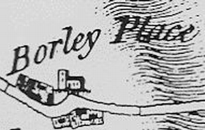
Although Borley Place, the farmhouse next to Borley Church, was used at various brief interludes as the rectory, it was on a plot of land on the south side of Hall Road that the successive rectories at Borley were built.
After the demolition of the final, and most famous, Borley Rectory, a small team of dedicated people excavated the ruins over a three year period. Their interest was focused on the cellars, due to Harry Price's sensational discovery of human remains under a concrete trough in the cellars. They determined that the cellars belonged to a previous building, but one that was much older than the Herringham rectory that had been demolished to make way for the 'Haunted' rectory of Henry Bull. In fact, they were able to say that the site had been occupied over a considerable length of time, to roman times or before.
Although they certainly had discovered the edge of the old rectory, they were digging in the wrong place if they wanted to get to the heart of the matter.
So where was the original Rectory?
Borley seems to have always consisted of three hamlets. It has never been a single village. There is the complex of Borley Mill and Borley Hall, down in the Stour Valley. On the crest of the valley side, with views towards Sudbury and Long Melford, is the Church, Rectory and farm of Borley Place. Further east is the separate hamlet of Borley Green. Hall Road originally joined the first two hamlets, and provided a drift road to enable livestock to graze the rich meadowland in the valley during the summer months. The church marked the junction of several pathways The most important was a road to the bridge over the Stour river, called Rodbridge (probably a corruption of Road Bridge) where, at the parish boundary, some gallows once stood. This road is now disused, and marked by a footpath. To the south was another driftway to the valley of Belchamp Brook, which Borley shared with Bulmer and Brundon. Due north from the church there was a path to Foxearth. Between the road to the Hall and the driftway to Belchamp Brook lay the glebelands and Rectory. The Glebe, on land owned by the Waldegraves, provided a small income for the Rector. The Rectory was sited to overlook this pastureland.
The presence of an older rectory is mentioned in various old documents, but only in passing, so we do not know its location for certain. For ecample, The Will of Nicholas Waldegrave in 1603 and 1615 mentions 'lease of rectory and parsonage of Borley with the mansion house'. However, the long triangle of land that held the later Bull and Herringham rectories is a prime candidate, being so near both the glebe and the church. It is possible that, some day, a map will be discovered that reveals more about the location of this ancient rectory.
There may have been several priests' houses over the centuries. For much of the time, the parish would be given to a trainee priest, a curate who would run the parish on behalf of an absentee rector or vicar. Their accomodation would be fairly humble. (in the eighteenth century, for example, the King's books list the value of the rectory as being nil.) If there was an ancient rectory, it would have been in use only when a rector was in residence. For a considerable period, the rectory was probably tenanted or unoccupied. Because the income of the rector was in the gift of the wealthy Waldegraves, it is likely that a rector would have been keen to take up the living. John Herringham, for example, gave up a career path that would have most likely taken him to a bishopric in order to settle in the little village, and his son Philip was happy to spend his whole career there.
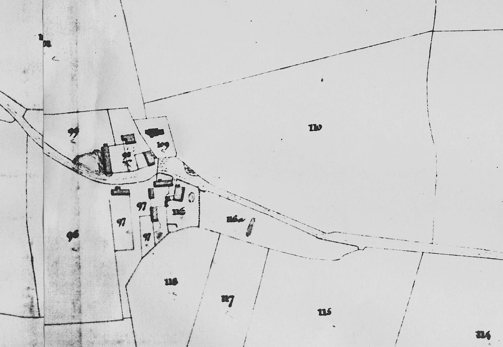
At the moment, the first map we have for the area is the Chapman and Andre Map of 1773. It shows two buildings on the site. The southerly one seems to be the rectory, oriented east/west, with the façade probably facing north. Unfortunately, detail is not great, but when one checks the mapping of Borley Place across the road, it seems to be reasonably accurate. One has to be careful of reproductions of this map, which seem to show detail which, on the original, can be seen to be dotted 'shading' to denote a garden or yard. There is a building by the road, exactly where the rectory cottage and stables were later sited, and one wonders if it is the same building refaced in brick (a common practice in Essex)
The next map is the 1806 Ordnance Survey. This is not particularly accurate and fails to show any building on the site except for the Rectory Stable. However, the characteristic shape of the garden, missing from the Chapman and Andre map, is shown as a 'plantation'. It was around this time that the Herringham rectory was being built.
The Herringham Rectory is shown in the 1841 tithe map. This shows the rectory house and garden. Once again, the Rectory Cottage and Stable is shown. The Herringham rectory was large, around the same size as Borley Place. It faced down the rectory garden, taking full advantage of the views. It was of the fashionable rectangular form and one imagines it as being of the pale 'Suffolk Galt' brick with the slate roofs that were then fashionable and cheap due to the coming of the canal to Sudbury. The area abounds with similar rectories built in this period. The driveway was at the side, in exactly the same place as the drive of the later Bull rectory, and there is an indication of an entrance porch facing the road.
The garden was the same size as the Bull one and included the two fields that were used as the pasture. The Glebe was ten acres in all.
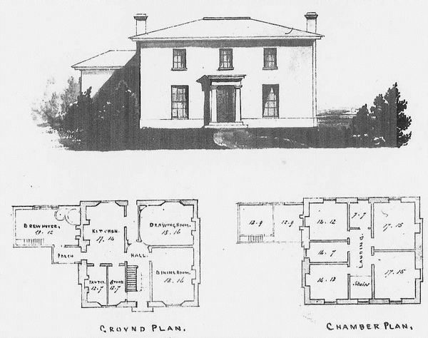
No, not the Herringham rectory but nearby Hartest, built just a few years later. It was a standard design for the time and the Herringham rectory would probably have been very similar
Rev H Bull demolished the Herringham rectory in order to build the famous 'haunted' rectory. The stable block was converted for the same use by the later Bull rectory. The Bull rectory was built partially over the Herringham one, particularly the kitchen wing. The Herringham rectory was quite large, though not so huge as the later rectory.
Henry Bull would have demolished the Herringham rectory and rebuilt because the principal drawing room would have been inadequate for the more lavish entertaining (dances etc.) that the Bulls were accustomed to do, and it was difficult to extend the existing drawing room. This was a common predicament with the handsome and otherwise practical rectories of the 1800s.. The Herringham rectory was ample in size for both father and son. However, in Herringham's time, marriages of the children of the Gentry and professional classes was 'arranged' during the 'season' at one of several regional centres. In East Anglia, they converged on Bury St Edmunds, where, for the month of the season, a string of parties and dances was arranged for the young unmarried children, whilst parents schemed strategic alliances by marriage. The Herringhams would not have been obliged to hold large parties from the Rectory. By the times the Bulls set up house, Bury St Edmunds was waning in its popularity and a lot more of the social life of the young 'gentry' was organised locally. To do this, grand houses needed large 'entertaining rooms' or 'Drawing rooms'. The Herringham rectory was elegant but fairly compact, and couldn't easily be converted to have the larger formal rooms. The Bulls were very social creatures and needed a grand set of formal rooms, and large kitchens, so they could act as host in style. This was a common problem at the time but, mercifully, a lot of the older houses could be converted to fit in with what were then the current demands for larger entertaining rooms.
So it seems that we have at least three rectories on the same site. As we have the maps, we can make a good guess as to where they are. The first thing we must do is to create 'normalised' versions of the old maps based on the accurate modern surveys. The normal way to do this is to determine which the constant features are, and 'stretch' the old map over the modern one. Here are the results.
Firstly, here is a reasonable guess of the original map, forced into compliance with the actual landscape. In doing this, we are lucky to have the church, tithe barn, Borley place, hay barn, and Rectory Cottage, all of which are there now. We also can locate a path that went from the drive gate to the rectory pasture through its more accurate rendition in the 1841 tithe map. This seems to have been the boundary of the garden of the previous rectory, There was another building around the yard of Borley Place, so it seems that the Farm was originally on that side of the road. The buildings on the south side could well have been part of the rectory's farm.
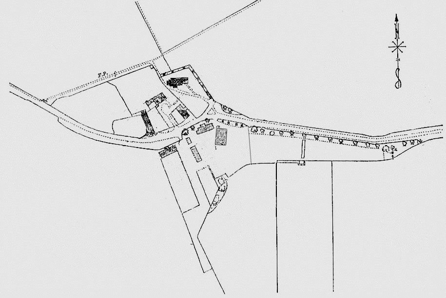
The Tithe map is easier to 'normalise', even though there were errors when one checks with a more modern map. The oddest anomaly was the misplacing of the cart shed in the farm next to the rectory. It is noticeable that the farm is only just beginning to spread down into the old driftway to Belchamp Brook. The Herringham rectory, fortunately labelled as 'Rectory House/Garden', is shown in all its glory facing down the broad cedars of the long rectory garden. It must have been a splendid view, with even an ornamental pond and stream (the latter dammed to hold water, and provided with a sluice)
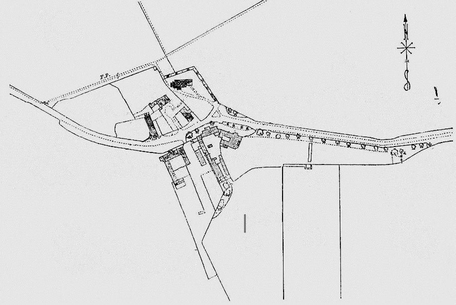
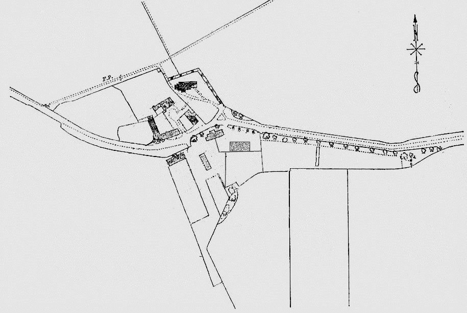
Lastly, we include the Ordnance Survey map of 1931, showing the Bull rectory. The Bull rectory seems to have taken on the Herringham theme of having the coach house behind, and the principal rooms of the house facing the long view over the lawns to the trees. However, the front of the house is rather further east, and directly over the post-mediaeval house. The back of the house is extraordinarily tight against the coach house and stables, particularly with the addition of the dairy. The addition of the south wing finally created the enclosed courtyard which must have made deliveries of coal and provisions by cart extraordinarly awkward. The architect seemed determined to make the front of the house coincide with the end of the post-mediaeval house..
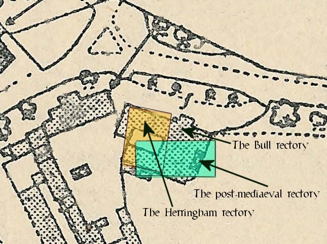
Now we have three reasonably accurate maps, we can superimpose them so as to get an idea as to how the various foundations and cellars would relate to each other. One can see that the three rectories were very close. The excavations of the 1950s missed the Herringham rectory altogether because that was more in the area of the courtyard and kitchen wing. This was under a great pile of rubble. The rest of the cellars of the original house would not have been initially built over since the courtyard was not enclosed by the south wing until later. The well would probably have been at the edge of the ancient house and outside it, although the excavators found another filled-in well in the old cellars. The oldest building seems a typical three-bay oak-framed building. The excavations would suggest a date of around 1550-1600. Cellars are found in buildings of this date, though one would expect them to cover at least the first two bays. There is a remarkable persistence in the siting of the rectory over the two rebuilds. The driveway would have been in the same place and the three buildings even seem to share a common stable and coachhouse.
Was it the rectory? The closeness of the glebe suggests that it was. Rectories were not always near the church but they usually kept near their glebe. As the rector was an appointee of the Waldegraves, it is likely that Waldegrave land would be used, and it would be reasonably near the hall. Whether or not the fact that an ancient building was on the site supports the idea of a haunting or not is another matter.