 This is a detail from the 1841 tithe map of Borley. The map shows the Herringham rectory described as 'Rectory house/garden'. (#116)
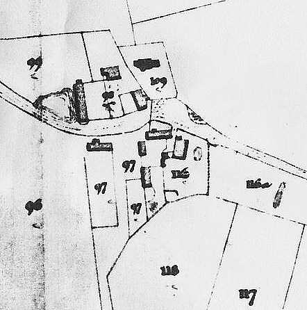
This is a detail from the 1841 tithe map of Borley. The map shows the Herringham rectory described as 'Rectory house/garden'. (#116)
The Herringham rectory was demolished by Rev H Bull in order to build the famous 'haunted' rectory. The Herringham rectory is built close to the stable block, which was later converted for the same use by the later Bull rectory. The Bull rectory was built partially over the Herringham one, particularly the kitchen wing. The Herringham rectory was quite large, though not so huge as the later rectory.
The garden was the same size as the Bull one and included the two fields (116 and 117) which were used as the pasture. A curiosity is a small pond to the east of where the later excavations turned up foundations of an earlier house. An earlier map, from 1773, shows a building somewhere near this pond but further to the west.
The 1773 map again shows a building on site of the Bull stable block. This is roughly the same size and shape as the Bull's stable block, and so it is likely that the building therefore survived.(brick sized hardly varied fron the 1620s onwards).
The map that is on page 149 of 'The Ghosts of Borley' by Peter Underwood seems to be a reasonably accurate tracing of this same tithe map. It was taken from a photographic copy in the Essex Records Office. The original still exists and probably has slightly more detail, which has become lost in the copying.
The angled walls are not the Herringham rectory. The bricks would have been indistinguishable from those used for the Bull Rectory if it had been. The cellars are from a much older building, almost certainly the one shown on the Chapman and Andre map of 1773. It was these cellars that would have been incorporated into the Bull cellars.
It looks as if the excavators never found the foundations of the Herringham rectory. One guesses that it didn't have cellars. I have a fair idea of what the Herringham rectory looked like because rectories at that date tended to be built to one of a limited number of patterns round about here and its squareness suggests one particular type.
Henry Bull would have demolished it and rebuilt because the principal drawing room would have been inadequate for the more lavish entertaining (dances etc.) that the Bulls were accustomed to do, and it was difficult to extend the existing drawing room. This was a common predicament with the handsome and otherwise practical rectories of the 1800s.. The Herringham rectory was ample in size for both father and son. However, in Herringham's time, marriages of the children of the Gentry and professional classes was 'arranged' during the 'season' at one of several regional centres. In East Anglia, they converged on Bury St Edmunds, where, for the month of the season, a string of parties and dances was arranged for the young unmarried children, whilst parents schemed strategic alliances by marriage. The Herringhams would not have been opbliged to hold large parties from the Rectory. By the times the Bulls set up house, Bury St Edmunds was waning in its popularity and a lot more of the social life of the young 'gentry' was organised locally. To do this, grand houses needed large 'entertaining rooms' or 'Drawing rooms'. The Herringham rectory was elegant but fairly compact, and couldn't easily be converted to have the larger formal rooms. The Bulls were very social creatures and needed a grand set of formal rooms, and large kitchens, so they could act as host in style. This was a common problem at the time but, mecifully, a lot of the older houses could be converted to fit in with what were then the current demands for larger entertaining rooms.
There may have been several priests' houses over the centuries. For much of the time, the parish would be given to a trainee priest, a curate who would run the parish on behalf of an absentee rector or vicar. Their accomodation would be fairly humble.
Wells were difficult and dangerous to construct and, as long as they continued to work, they were reused. I would guess that the well would have been old when the Bull rectory was built. tithe maps were only interested in fields and field boundaries. They do not show wells.